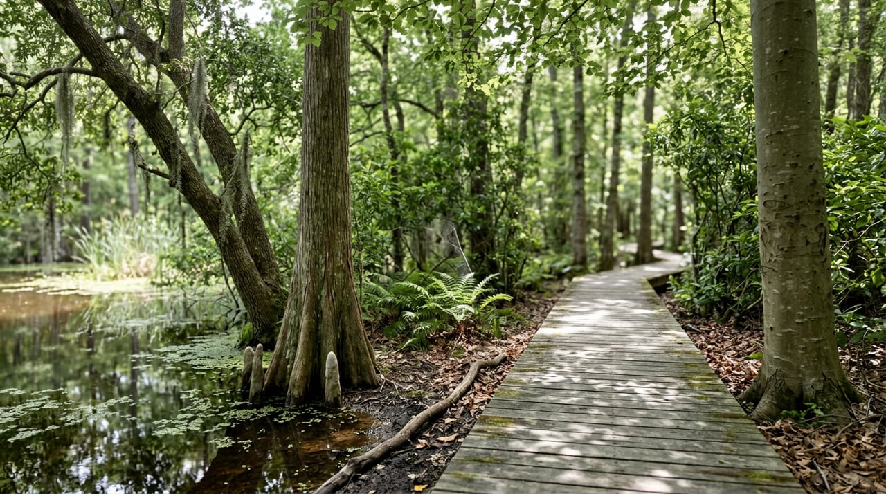
Nags Head Woods Trail Conditions: Why Ponds Recover Slowly
August 27, 2026
August 27, 2026
Walk the ADA Trail at Nags Head Woods Preserve in late August and the ponds look better than they did in June. Not full. Better. The distinction matters more than it sounds, because the North Carolina Drought Monitor has been calling the Outer Banks corridor drought-free since July 30, 2026, and anyone checking that map before heading out with a dog or a pair of binoculars would reasonably expect the preserve's freshwater ponds to have bounced back weeks ago. They haven't, not entirely, and the reason has less to do with rainfall totals than with what's underneath the trail.
The dry stretch was real and it built for months. State climatologists tracking the region through the spring noted that the Outer Banks and northeastern North Carolina had gone through several months of below-normal precipitation, concentrated during the spring growing season. By the assessment period ending June 9, 2026, severe and extreme drought had expanded across eastern North Carolina, and exceptional drought, the most severe category the U.S. Drought Monitor uses, had reappeared elsewhere in the state for the second time that spring.
Then the rain came. Widespread totals of 3 to 6 inches fell across eastern North Carolina in the week leading up to July 30, and nearly every county saw its drought status improve by at least one level. Counties running from the Albemarle Sound to the Pamlico Sound, the Outer Banks corridor included, were removed from drought conditions altogether. It was the first time any part of the state had been fully drought-free since August of 2025, close to a year earlier. As of the most recent updates on August 13 and August 20, 2026, that status has held along the sounds and the Outer Banks, even as moderate to severe drought continues inland.
On paper, the woods should be fine. On the trail, the ponds are still telling a slower story.
Nags Head Woods isn't fed by a river or a reservoir. The preserve, more than 1,200 acres managed by The Nature Conservancy, sits in a landscape of relict sand dunes, the fossilized remnants of dune ridges that formed centuries ago and have since been colonized by oak, hickory, and beech. Between those old dune ridges are low troughs that hold water, and that stored water is what keeps the maritime forest green even when the surrounding region dries out.
Lora Eddy, the preserve's conservation coordinator, explained the mechanism to Coastal Review reporter Kip Tabb in a June 2026 piece documenting the dry conditions:
"areas between our relic dunes hold rainwater and help provide a little bit of extra water for the forest"
That storage system is slow by design. It fills gradually, it drains gradually, and a single wet week in late July doesn't reset it the way a drought monitor's category shift might suggest. Tabb's reporting noted that more than 14 acres of woodland habitat along the Roanoke Sound had already been drying out for several years before this spring, with the freshwater ponds showing the cumulative effect. A multi-year deficit doesn't close in a month, even a rainy one.
What this means for anyone who actually walks the trails is that late summer 2026 is a transition period, not a finish line. The ponds along the Discovery Trail and the brackish marsh overlook on the ADA loop are visibly higher than they were in June, and the forest itself never stopped looking lush. Eddy's own description of the preserve during the dry stretch was of a woodland that stayed vibrant green even as the ponds thinned, a sign of just how much buffering capacity those dune-trough reservoirs provide.
The wildlife hasn't paused for any of this. Nags Head Woods still hosts more than 150 documented bird species, upward of 50 of which nest there, and the preserve's mammal list recently grew to include a bobcat, an animal uncommon enough on the Outer Banks that its presence gets specifically called out in the preserve's own materials. None of that required full ponds. It required the kind of layered habitat, oak canopy, brackish marsh, freshwater pond edge, and dense understory, that a slow-draining, slow-filling dune system creates almost by accident.
The preserve's entrance hasn't changed regardless of rainfall. Locals headed to the trailhead from US 158 turn west near milepost 9.5 onto Ocean Acres Drive, at a stoplight anchored by a McDonald's and Pigman's BBQ. From there the road runs through a residential stretch for about a mile before narrowing to gravel, curving sharply, and opening onto the preserve's parking area. The final stretch is jointly maintained by Kill Devil Hills and Nags Head, capped at 15 miles per hour, and narrow enough that meeting an oncoming car means someone backs up to let the other pass. It is not a road built for volume, and that's part of what keeps the preserve from feeling like the rest of the beach in August.
Once you're parked, the preserve breaks into eight numbered trails, ranging from the fully accessible half-mile ADA loop to longer routes that push out toward Roanoke Sound. A few practical points worth knowing before you go:
For a place tucked a mile off the highway behind a gravel curve, Nags Head Woods sees real use. A Nature Conservancy regional steward told Our State magazine that the ADA Trail alone draws around a thousand visitors a month, a number that holds up against the preserve's reputation as an overlooked alternative to the beach. That volume shows up in small ways, worn spots on the boardwalk, a steady stream of dog walkers in the cooler morning hours, birders comparing notes at the marsh overlook.
The preserve's place in the community runs deeper than foot traffic. Every year, the Saturday before Mother's Day, the First Flight Rotary Club hosts the Nags Head Woods 5K along Old Nags Head Road, one of the oldest roads in Dare County. The race hit its 40th running in May 2026, a four-decade streak that says something about how long this particular stretch of woods has mattered to the people who live around it, long before anyone was tracking drought categories or dune hydrology.
That's the piece worth carrying into the rest of the season. The drought monitor cleared the Outer Banks corridor back in July, but the preserve's ponds are working through a deficit that built over years, on a timeline set by sand and old dune ridges rather than a weekly weather report. If the water still looks a little low on your next walk through, it isn't a sign that anything's wrong. It's a sign the system is doing exactly what it was built to do, just slower than the map suggests.
If you're weighing what living near a place like this is worth, or thinking about how a property near the preserve fits into your plans for the Outer Banks, Brook Sparks can walk you through what's actually for sale in Nags Head right now and what it takes to own here well. Request your CB Estimate® & Owner Consultation to get a clear, local read before you decide anything.
Stay up to date on the latest real estate trends.


I provide expert guidance for buyers, investors, and property owners looking to maximize value in coastal real estate. By understanding each client’s goals—whether lifestyle-driven or investment-focused—I help identify properties that align with long-term success. My services also include consulting for existing owners, with strategies focused on pricing, performance optimization, and simple improvements that increase revenue and visibility year-round.